
05-09-12
Spent last night in a car park specially for campervans in a
charming little village, Vordernberg on the eastern side of the Eisenzer Alpen.
Then in the morning headed into the Gesause National Park.

 |
| Hochtor's north wall from Gr Buchstein |
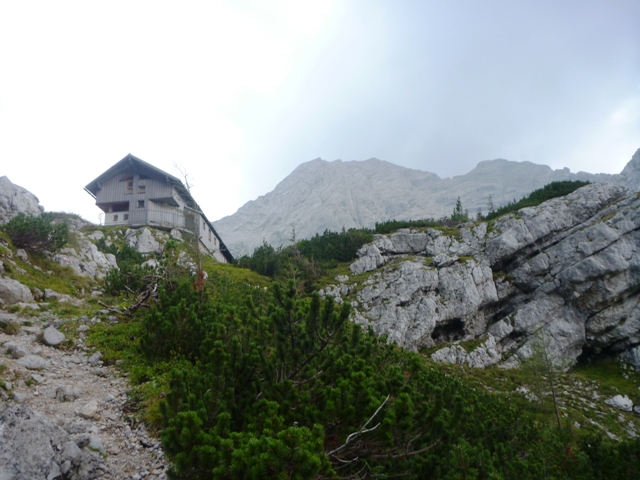
On a British OS map, tracks are generally and simply referred to as either footpaths, public footpaths or bridleways. On the freytag & berndt maps there are three kinds of tracks. A continuous red line is for 'a path for hiking or strolling, easily passable on foot'; a dashed red line denotes 'path for hiking in the mountains; whereas a dotted red line is 'Alpine steep track for mountain-experienced hikers with steady steps and with a good head for heights, route partial scramble'. If I was going to get to the Hesshutte refuge at 1699m I was going to have to develop some 'steady steps'.
As an ascent route it was OK, there were several stretches of via ferrata, not all of it really needed when ascending in the dry and useful step ladders up the vertical bits. There was just one point where I wondered how I would I cope with on descent. The path then entered Ebbrsanger, a steep wooded hanging valley and right at the top of the valley is the Hesshutte precariously hanging over the edge.
 |
| Ebbersanger valley - with a tiny Hesshutte at the top |
 | ||||
| Hesshutte from below |
 |
| Hesshutte from the start of track 664 |
It looks like all the tracks in Austria are marked with a red square and a horizontal white line - similar to the Austrian flag. So, you have to double check you are following the right track - and I think it could be easily confused with a no-entry sign.
 |
| Looking down on a tiny Hesshutte |
 |
| A 'steady steps' section on the Hochtor summit ridge |

The summit is marked by a big metal cross - I was going to discover that is not a rarity on Austrian summits - and, in a metal box, there was a logbook to complete, with a plug for this blog duly added.
So all I needed to do was reverse the route. If I could get to the hutte before 17.00 I would carry on down to easily beat the dusk at around 19.30. If I was later than that or the weather turned for the worse I would seek refuge.
 |
| Looking back across the Hochtor ridge |
I passed the hutte just before17.00 and although there were clouds in the sky I decided to carry on, without even stopping for another cup of tea - and certainly not a beer. I made good time down the valley to the top of the giant wall - and started down the via ferrata. And then the weather turned - the lightning and thunder came repetitively and close. The rain was torrential - I had some shelter from the buttresses above me, but I knew that I could not hang around as I certainly did not want to be there in the dark.
I was soon quite wet and using metal via ferrata in a thunderstorm generated in me a range of interesting emotions. Most interesting to me was that 'panic' wasn't one of those emotions. Do I turn back and go to the hutte wet through and no change of clothing or do I carry on. I carried on down the wall, across the now raging waterfall and down into the trees and their roots. Much lower down I realised that if I kept with the stream that had been the waterfall I could get down to a reservoir in the valley below. So I ignored the marked trail as it turned away from the stream, which eventually became culverted and it brought me out on an unpaved road just as the dusk light was low enough to have made those tree roots a problem. The unpaved road took me right back to the start point.
As for the rain - that continued for the next 24 hours. If I had gone back to the hutte I would have still had to tackle the via ferrata in the wet and if I had waited for the rain to stop before continuing, it would have been a long wait.
But hey, that's another Ultra.


No comments:
Post a Comment