23-05-2013 – 24-05-2013
The whole of Portugal was enjoying bright sunshine – except for
the Serra de Estrala – as I toured the various serras (hill ranges) looking for
Majors. Glad I did it as I saw a side of the depopulated rural side of the
country that I would not have seen otherwise.
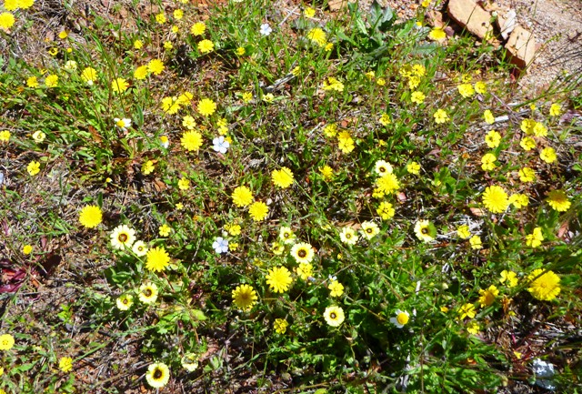
It looks like much of the country has been abandoned to agricultural ‘set-aside’
with uncared groves of olive trees and vast areas of uncultivated land,
resulting in an astonishing and abundant display and range of wild flowers.
I thoroughly enjoyed the journey – and the relatively
trivial task of bagging the hills from high start points.
Serra de Montemuro/Talegre
 The most northerly of the Portuguese Majors that I visited
is on the Serra de Montemuro, a nature reserve, which would be quite attractive
with its wealth of wild flowers and the many scattered boulders that reminded
me of Kinder Scout, except that the whole thing is a giant wind power station. Because
of the power station it is possible to drive to very near the summit by turning
off the N321 at Portas Bar petrol station (1208m) N40.96623 W8.00812.
I parked at
N40.96959 W7.99168 (1336m), although it is possible to park at N40.97262
W7.98828 (1340m), just to give my legs a stretch. The top which is named
Talegre or Talefre is a Major 1382m P833 at N40.97398 W7.98778 is like a
Dartmoor tor with a large obelisk and a trig point. As I explored and clambered
over the rocks I could hear church bells which reminded me of hearing something
similar in the mist on Slieve League, County Donegal.
Lovely flowers. Horrible windmills.
1.76km, 104m ascent
It seems that wherever you are in mid Portugal there is a
view of the Serra de Estrala and signs pointing towards it, until you get up
close. Whereas the rest of Portugal was enjoying sunshine the Estrala, like Cross
Fell, had its own weather system – and today there was a large cloud just above
the summit.
After a bit of confusion where two exits from the same
roundabout were signed to the Serra de Estrala I managed to find the road that
winds its way from north to south over the top. I pulled up in the carpark near
the summit by a group of nuns who appeared to be performing a scene from Father
Ted – one of them was flapping her arms and making loud bird noises.
The summit has a number of buildings, markers and
communication globes on its summit these include a torre/tower, three trig
points (one of which on a tall plinth) and a couple of shops that smell very
much of a strong cheese on sale. The summit, Malhao da Estrala/La Torre happens
to be Portugal’s highest point, a Major 1991m P1202 N40.32190 W7.61291 still
bore traces of snow. Not much of a view from the actual summit, but more extensive ones from lower down.
Serra da Gardunha
 I spent a while driving up tracks – afterwards, despite the
windows being closed, the interior of my motorhome was covered in a layer
of dust – to arrive at a point where I
feared for the chassis of my motorhome to continue any further after N40.09885
W7.50851 (1101m). From there it was
simply a matter of following a dirt track to a summit with an obelisk, in
amongst the detritus of summit masts and the wild flowers.
Its name? Serra da
Gardunha Major 1227m P770 N40.08076 W7.52572. Wide, if hazy, views all round
Overnight in a designated area for motorhomes by a large
artificial lake, found by chance in the town of Vila Velha de Radao just as I
was beginning to wonder where on earth I could stop.
Pico Sao Mamede
 The next morning I set off to Portalegre and then up on to
the flower covered Serra Mamede. There is a road all the way up to the top of Pico
Sao Mamede Major 1025m P659 N39.31346 W7.36060 . I parked by the masts at
39.31327 7.35979. The summit is marked by an elevated trig on top of some rocks.
There were extensive views across Portugal and into Spain.
Then it was off to meet Patrick in Lisbon/Lisboa, which was
enjoying a heat wave. And to find where all the people had moved to when they left the rest of Portugal.
Overnight in the Holiday Inn, Lisboa.


No comments:
Post a Comment