Translate

Thursday, 30 May 2013

Bottom left corner

28-05-2013 - 29-05-2013

After dropping off Patrick at the place where people disappear into the sky, I drove over the Tagus had a quick look at the Cristo Rei and then started a long drive south. Overnight in an Estacao Servico Autocaravanas in the small resort of Porto Covo south of Sines.


I made a quick visit to Foia the highest point on the Serra de Monchique - a Major 902m P739 - when I say the highest point, I mean the highest you can reach by the fence of the Radar station, only a few metres from the obelisk and trig point. How frustrating. And what a mess of  human-made construction the summit area is. A good hazy view of the sprawl of resorts in the Algarve to the south. The serra itself seems to be a giant plantation of eucalyptus trees


The Atalantic from Foia
A year ago I went to the point where the Baltic and the Atlantic meet at Grenen in Denmark - see http://oakesave.blogspot.co.uk/2012/07/went-up-to-danish-most-northerly-point.html

So, I thought I would go to the point where the Mediterranean meets the Atlantic. I know that this is not the same as arguably that point could be at the Gibraltar straits. And the waves does not literally crash against each other here.

The Romans considered Cabo de Sao Vicente to be at the end of the world - the Promontorium Sacrum - and it apparently has the most powerful lighthouse in Europe. The way the lighthouse is built it is impossible to get to the edge of the cliff at the extremity of the cape, despite attempts to clamber past it on the 60m high cliffs.
Cabo de Sao Vicente

I also visited the Point of Sagres which is defended by a fortress that was originally built by Henry the Navigator and tried to stand at the most southerly point of the point.

Henry the Navigator's pebble wind compass - the Rosa dos Ventos
Cannot say that I was impressed with what I saw of the rest of the coast of Algarve - a continuous nightmare of seaside resorts.
Overnight in the Parque de Palmeira, Albufeira.

West end boys

27-05-2013
Serra da Sintra
The end of Europe
As a hill-bagger who is always on the look-out for the extremities of  altitude it was a matter of no-choice and compulsion to visit an extremity of longitude. The Cabo da Roca is the most westerly point in mainland Europe. Even if it had been an oil terminal I would have felt compelled to go. As it turned out it was more pleasant than that.
We headed out of Lisbon to the UNESCO World Heritage site of the Serra de Sintra. At the east end is the highest point of the serra, Cruz Alta (530m) in the grounds of the Palacia da Pena. I toyed with the idea of bagging it - however, the tourists crowds were so dense and the parking so difficult I did not bother. Instead we drove to the other end of the Serra and ascended the pointed top of Peninha (499m) with a chapel built on to the top of the rock. From there were extensive views of the Atlantic and back along the serra. And there were only a handful of other tourists.


That's Cabo da Roca in the background - me at Peninha
Patrick at Peninha
At the Cabo da Roca there were rather more tourists, but it was not heaving with them. There was a heavy invasion of ice-plant - Carprobrotus edulis. After inspecting the plaque on the obelisk N38.78045 W9.49894 it was obvious that there was a little further west to go. I stood on the cliffs as near to the edge as possible at N38.78045 W9.49907 - however, there did not seem to be a way of getting down to the narrow shore below.
Cabo da Roca lighthouse
Just a bit further west - inaccessible, though
Just a bit south-east of the obelisk I found a path down - part of it aided by a fixed rope. I managed to get down to the shoreline there, but it was not possible to go back northwards to below the obelisk. Facing me was a stack with a fixed line running to the top. I debated about having a go, but decided against as I had not mentioned to Patrick that 'I may be some time'.


Stack with fixed line
Arte Maritime - Estoril
Lisbon from across the Tagus

Tuesday, 28 May 2013

Lisboa/Lisbon

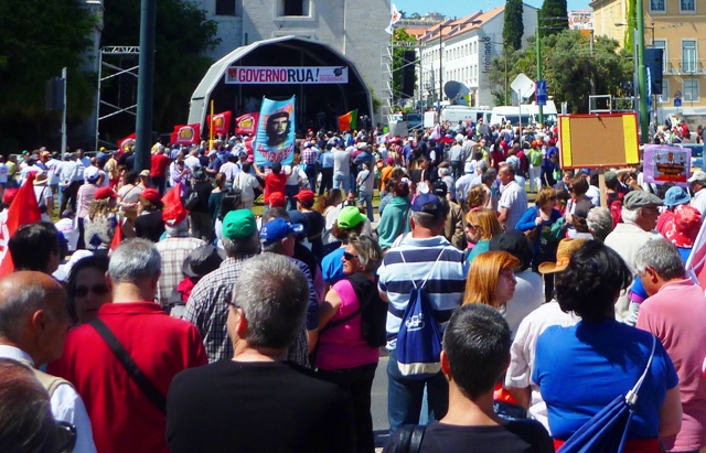
March and rally against austerity
24-05-2013 – 26-05-2013


Now I know where all the people from the rural areas have gone – they all seem to live by the river Tagus in Lisbon and its satellite towns. And this is where the tourists come.
I am ignoring the Algarve for now.
Lisbon is big and full. As most cities it has a bubble in the middle where most local people rarely visit. Patrick and I explored the bubble. We looked at buildings such as the Torre de Belem; rode on trams, buses, the metro trains and the Elevador de Santa Justa; we visited Art galleries – the Museu Nacional de Arte Antiga and the excellent Museo Coleccao Berardo in Belem; we got involved in an anti-austerity rally and march outside the President’s residence, the Palacio de Belem; we enjoyed an evening in a Fado restaurant in the Alfama district; we tried to find Henry Fielding’s gravestone but the cemetery was closed, we sat in the Jardim de Estrela and listened to the band playing as people danced in the park.

Lisboa tram

Monument to the Discoveries - Padrao dos Descobrimentos


Torre de Belem


Portuguese Majors


23-05-2013 – 24-05-2013 
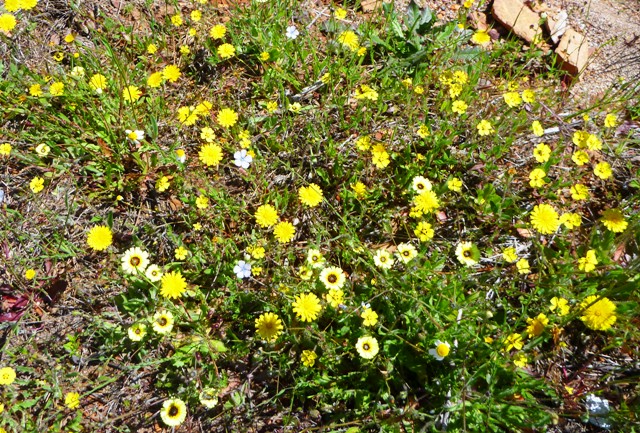
The whole of Portugal was enjoying bright sunshine – except for the Serra de Estrala – as I toured the various serras (hill ranges) looking for Majors. Glad I did it as I saw a side of the depopulated rural side of the country that I would not have seen otherwise.  It looks like much of the country has been abandoned to agricultural ‘set-aside’ with uncared groves of olive trees and vast areas of uncultivated land, resulting in an astonishing and abundant display and range of wild flowers.
I thoroughly enjoyed the journey – and the relatively trivial task of bagging the hills from high start points.


Serra de Montemuro/Talegre   
The most northerly of the Portuguese Majors that I visited is on the Serra de Montemuro, a nature reserve, which would be quite attractive with its wealth of wild flowers and the many scattered boulders that reminded me of Kinder Scout, except that the whole thing is a giant wind power station. Because of the power station it is possible to drive to very near the summit by turning off the N321 at Portas Bar petrol station (1208m) N40.96623 W8.00812. 


I parked at N40.96959 W7.99168 (1336m), although it is possible to park at N40.97262 W7.98828 (1340m), just to give my legs a stretch. The top which is named Talegre or Talefre is a Major 1382m P833 at N40.97398 W7.98778 is like a Dartmoor tor with a large obelisk and a trig point. As I explored and clambered over the rocks I could hear church bells which reminded me of hearing something similar in the mist on Slieve League, County Donegal.


Lovely flowers. Horrible windmills.
1.76km, 104m ascent


Malhao da Estrala/La Torre 
It seems that wherever you are in mid Portugal there is a view of the Serra de Estrala and signs pointing towards it, until you get up close. Whereas the rest of Portugal was enjoying sunshine the Estrala, like Cross Fell, had its own weather system – and today there was a large cloud just above the summit.


After a bit of confusion where two exits from the same roundabout were signed to the Serra de Estrala I managed to find the road that winds its way from north to south over the top. I pulled up in the carpark near the summit by a group of nuns who appeared to be performing a scene from Father Ted – one of them was flapping her arms and making loud bird noises. 


The  summit has a number of buildings, markers and communication globes on its summit these include a torre/tower, three trig points (one of which on a tall plinth) and a couple of shops that smell very much of a strong cheese on sale. The summit, Malhao da Estrala/La Torre happens to be Portugal’s highest point, a Major 1991m P1202 N40.32190 W7.61291 still bore traces of snow. Not much of a view from the actual summit, but more extensive ones from lower down.


Serra da Gardunha 
I spent a while driving up tracks – afterwards, despite the windows being closed, the interior of my motorhome was covered in a layer of  dust – to arrive at a point where I feared for the chassis of my motorhome to continue any further after N40.09885 W7.50851 (1101m). From there  it was simply a matter of following a dirt track to a summit with an obelisk, in amongst the detritus of summit masts and the wild flowers.


 Its name? Serra da Gardunha Major 1227m P770 N40.08076 W7.52572. Wide, if hazy, views all round

Overnight in a designated area for motorhomes by a large artificial lake, found by chance in the town of Vila Velha de Radao just as I was beginning to wonder where on earth I could stop.

Pico Sao Mamede 

The next morning I set off to Portalegre and then up on to the flower covered Serra Mamede. There is a road all the way up to the top of Pico Sao Mamede Major 1025m P659 N39.31346 W7.36060 . I parked by the masts at 39.31327 7.35979. The summit is marked by an elevated trig on top of some rocks. There were extensive views across Portugal and into Spain.


Then it was off to meet Patrick in Lisbon/Lisboa, which was enjoying a heat wave. And to find where all the people had moved to when they left the rest of Portugal.


Overnight in the Holiday Inn, Lisboa.